Storm season is officially here. I start my season off in Oklahoma City, OK. I have only one day available to me. For this would be the year that I’ve really dedicated my off time to learning everything I can. To not only keep myself safe but to be successful in positioning myself for some amazing images. The NOAA Storm Prediction Center (SPC) has given the 1 Day Outlook for severe weather a rating of “Slight Risk” which is a level 2/5 rating.
On the morning of April 3, the first thing to do is to go through weather models and to read the update from the SPC which goes out around 7 am. The models still are pointing to the Texas panhandle and Oklahoma border with initiation at around 4 pm. I'll generally pick a middle ground within the risk area so that when I arrive I’ll more locations available if the models change. The current risk area puts me at about a three-hour drive. So with this determined, my latest time to leave is 12 pm. So for the rest of the morning, I'll keep looking through each new hourly model just in case a new area becomes of interest.
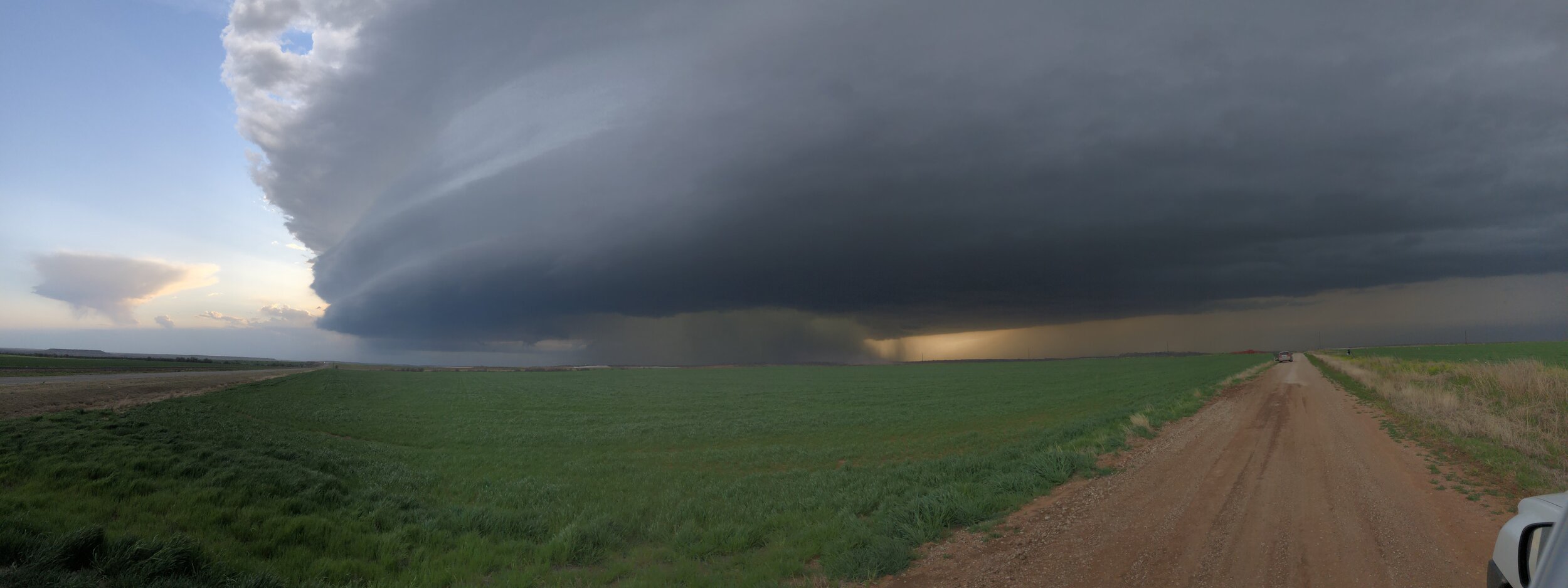
I leave OKC at noon today to give myself a little bit more time when I arrive to survey the cloud structures that may or may not be forming. I arrive just outside Hollis, OK. There is already a nice towering cumulus structure forming and I can quickly tell where the "Rain-Free Base" is at. Normally when arriving this early. I'm be stressing over where and when a storm cell will pop, the dreaded waiting game. Now that I'm on this cell and there is no other activate. I'll follow this for the time being. The storm's updraft was growing with intensity causing a lot of these dry fields to turn into little dust storms. At this point, I have made a rookie mistake. I waited to long to drive ahead of it. So now I’ll have to wait for it to pass to then drive around. I could punch through the core but its not worth it for safety reasons, so I can’t be that upset. Now with this choice, I have now set myself up to drive 85 miles around to get back on the cell. This drive around would actually prove to be worth it because it set me up for some amazing supercell structure timelapse video. This is definitely noted for future chases that you don't have to be right on the cell for some great shots. Now that I'm back with the storm cell and with the time spent driving around to get back with it. It has increased in severity and size. This is where I make rookie mistake number two. I arrive at a dirt road to take some pictures just outside Olustee, OK. I now have the decision to either take off and try to get ahead of it on the next highway or stay and photograph it as it passes on by. I decided to take off which turned out to be the wrong choice. On radar, it looked like I had enough time to just skim by the front of the cell and miss any kind of rain or hail but that proved untrue. I now had to drive through some intense hail the size of marbles. At the intensity of the downpour, thus has slowed me down to 30 mph. I pull over in Altus, OK to wait out the hail and at this point I call the chase off. I have run out of daylight. This one chase given me confidence in picking target locations and also learning even more about severe thunderstorm structure.